After six months of discussion and multiple options, the City Council majority has opted for a map that some say is the clearest choice for dividing San Clemente into voting districts because it cleanly splits the community along major arterials, canyons and the freeway.
The council settled on the boundaries for creating four voting districts that will go into effect starting with the November election after the city attorney said a new law, the Fair Map Act, prevented the council from considering other maps after Jan. 1 without creating an independent panel of residents to start a new redistricting process.
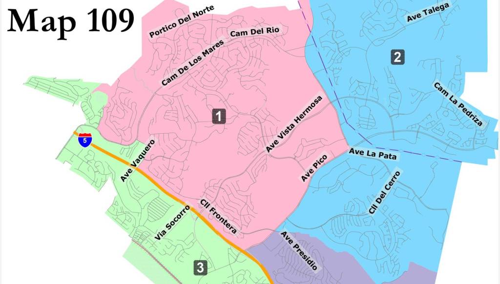
The map the city will use for its new district-based elections, known as Map 109, was the last one the council approved before the new law went into effect at the start of the year.
At least 30 residents representing the Southwest Community Association tried at the council’s latest meeting to convince it to change from Map 109 to another version that is similar, but doesn’t split a Pier Bowl neighborhood.
But the council split on creating a new independent panel and the circumstances did not meet the criteria for an exemption from the requirement to now use one, which include following a court order, settling a legal claim, if there was a city boundary change, or if there were a decrease or increase in the number of council members.
Since there were no exemptions that fit, two council members, Chris Duncan and Mark Enmeir, asked their colleagues to support the independent panel but failed to get support.
“If we want to meet our March deadline, this is our only option,” Mayor Victor Cabral said of moving forward with the already approved Map 109.
Map 109 makes the Talega and Rancho San Clemente communities one district and Forster Ranch and Marble Head another. The other two districts along the beach are divided by Avenida Victoria. One district goes toward North Beach and the other goes south toward Cypress Shores. From there, it crosses the 5…
Read the full article here


