Come November, Cypress residents will begin to choose who will represent them on the City Council based on where they live.
The switch to by-district elections is the culmination of a years-long lawsuit challenging how residents have elected their councilmembers.
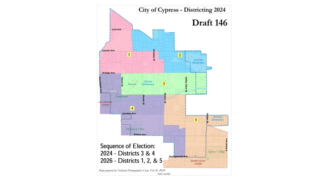
Now, after the City Council in a split decision has approved a map for how the city will be carved into districts and a sequencing system for when seats will appear on the ballot, voters will choose only one councilmember who lives in their district every four years, starting with the November election.
Cypress is split into five districts with the new map, with District 1 being in the northwest corner from Acacia Circle down to Orange Avenue, including Forest Lawn Cemetery, Evergreen Park and Willow Park.
District 2, in the northeast, picks up Arnold Cypress Park and Cypress College, ending at Orange Avenue.
A rectangular shaped District 3 is in the middle of the city, its boundaries including Orange Avenue to the north, Holder Street to the east, Ball Road to the south and Denni Street to the west. This district includes Veterans Park, Cypress High School and Oak Knoll Park.
District 4 zigzags down the southwestern portion of Cypress, picking up Los Alamitos Race Track, Costco and Cedar Glen Park.
District 5 juts around the southeastern corner of the city and wraps back west to include a portion of the city just to the south of District 4, from Orangewood Avenue south to Apia Drive and Eucalyptus Park. Along with that corner, it includes everything east of Valley View Street and south of Cerritos Avenue before coming back across to pick up neighborhoods around Laurel Park all the way up to Ball Road and Walker Street.
Residents can find an interactive version of the map online and determine which district they will cast a ballot for.
Councilmember David Burke said he believes transitioning to district elections will net some positives for the city — like making it easier for…
Read the full article here


